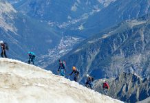
Mt. Baldy is the highest peak in Los Angeles county and is a popular and difficult hike that’s just over an hour outside of the city. It’s official name of Mt. San Antonio, but it’s called Mt. Baldy since the top is tree-less and “bald”. It’s often used for training for other more strenuous hikes. During our trek, we encountered people who were using it to train for Mt. Whitney, Half Dome, and the Himalayas.


This hike is no joke! It’s very steep in some sections and has a pretty significant elevation gain.
Overview
- Distance: 10-12mi
- Type: Out & Back (could make it a loop)
- Time: 6-8hrs
- Elevation at trailhead: 6,000 feet
- Elevation Gain: 4,064ft
- Difficulty: Strenuous
- Crowd Factor: Moderate-Low
- Best Time: June-Sept
- Permits: No
- Water: No
Choosing Your Route & Hiking Trail Map
There are a few options for hiking this mountain to the summit. It can be done as a loop or up and back along the same trail. You’ll want to check the conditions of the trails before choosing your route (see more below about safety).


There are a few possible starting places for either hike.
- Manker Flats Campground parking lot – Elevation 6,000ft
- Ski Area parking lot – Elevation 6,500ft
- The Notch Restaurant – Elevation 7,800ft
You need a parking pass for both Manker Flats and the Ski Hut: a National Parks Pass, an Adventure Pass, or buy a $5 day permit from the visitor’s office.
Ski Hut Trail & Devil’s Backbone Loop
This loop will take you all over the entire mountain. The most common route for the loop is to go up The Ski Hut Trail along the Baldy Bowl to The Summit, and then down The Devil’s Backbone to The Notch Restaurant, then down the Fire Road back to the parking lot.
This route is roughly:
- Distance: 11.5mi
- Elevation Gain: 4,064ft
Up and Back Hikes
You can go up and back via either The Devil’s Back Bone Trail (and The Notch) or The Ski Hut Trail.
The Notch then the Devil’s Back Bone to the Summit::
- Distance: 12.8mi
- Elevation Gain: 4,064ft
OR
The Ski Hut Trail to the Summit:
- Distance: 10.8mi
- Elevation Gain: 4,064ft
The Devil’s Back Bone Trail is longer than the Ski Hut Trail, but it’s also less steep and you don’t gain as much altitude as quickly. The Devil’s Back Bone also gets more sun than the Ski Hut Trail, so there’s often less snow/ice.


Pretty much ever single thing I read before doing this hike says that the elevation gain for the hike is 3,990ft. BUT, the elevation at the Summit is 10,064 and the elevation at Manker Flat is 6,000ft, which would make the elevation gain 4,064ft, so I’m not sure where the 74ft discrepancy comes from.
Easy Option/Alternative: The Mt. Baldy Ski Lift is operational from 8-5pm (6pm during the summer) for $15 one way. You can take the ski lift up/down from the Ski Lift parking lot to The Notch, so you could start the hike from The Notch at 7,800ft if you wanted to.
Distances Between Points Along The Trail
Manker Flats to The Ski Hut Trail Head
The Ski Hut Trail Head to The Summit via Baldy Bowl
|
Manker Flats to The Notch via The Fire Road
Ski Lift Parking Lot to The Notch via The Fire Road (the “short cut”)
The Notch to The Summit via The Devil’s Back Bone
|
Directions To The Trail head
If you’re starting at Manker Flats, park at the campground and then continue to walk further up the road to the trail head (there are signs). Maker Flats is a more popular place to start, so the parking here is more competitive. You’ll see cars parked all over the side and center median grass area. Find a spot wherever you can. Be sure to get there early to make sure you find a spot.
If you’re starting at the Ski Hut parking lot, continue past Manker Flats Campground, continuing to follow Mt. Baldy Road. The road will go left (there will be a large wooden sign for Mt. Baldy) and wind through a series of switchbacks until you reach the Ski Hut Parking Lot. From there the Trail Head for the “short cut” is at the end of the parking lot.
Drive from Los Angeles: 1 hour
Drive from Palm Springs: 2 hours
Drive from San Diego: 3 hours
Safety: Prepare Before You Go
Located just outside of Los Angles, there can be a few surprises with this hike that makes it unlike other “Los Angeles hiking”…. for starters, it’s a giant fucking mountain and not just a hill. If you’re not prepared, you could end up in real trouble or not be able to complete the hike. Do your research and be prepared.
Snow!
Even in the Summer! You can expect to have snow on the trail from Jan to May, and the potential of it snowing starts again around late Sept. This can be a very dangerous hike in bad conditions.


We did this hike in mid May, and there was snow, but it was passable via paths had been cut into the large portions of snow. There wasn’t much snow on The Devil’s Backbone, however the Ski Hut reportedly had a lot more snow and even ice, which made it very difficult to hike.
Two weeks later, one of the friends I did the hike with went back to do it again as part of the Climb For Heroes and these were the conditions:
View this post on Instagram
Before starting your hike, check the snowfall report for The Notch Restaurant available here. This will give you an idea of what you can expect on the trail and the gear you will need to bring, which may include cramp-ons to get you through the snow.
Wind & Cold
Even if it’s not snowing and the trail is passable, the summit of Mt. Baldy tends to be very windy. It’s one of the highest peaks around and doesn’t have any trees to break up the wind, so it’s completely exposed to the elements. Plan on the wind chill dropping the temp at the summit another 10 degrees. You will likely want to bring a windbreaker and gloves. You can check the weather at the summit here.
The majority of the time when planning your hike, ideally you’ll want to try to hit the Summit between 1-2pm, which will be the warmest part of the day. Unless you’re hiking during July/Aug when the temperatures are warmer and days are longer, if you don’t reach the Summit by 3:30, you should turn back for risk of it getting too cold or too dark before getting back down.
Altitude
The Summit of Mt. Baldy is just over 10,000ft. The elevation gain depending on where you start hiking is likely going to be around 4,000ft. That’s a big change. If you’re not use to it, hiking at this elevation can cause headaches, nausea, and dizziness from the air being thinner. Take it slow, drink lots of water, and take breaks as needed to catch your breath. Here are some other tips on how to avoid/recover from altitude sickness.
What To Expect Along The Trail
I did this hike with @msadelatirado and @stephaniepanisello
The first time we did this hike, we started at the Ski Lift Parking Lot, went up the Fire Road to The Notch, up The Devil’s Back Bone to the Summit, and then back down.
The second time we did this hike, we started at Manker Flats, went up via the Ski Hut Trail, and then back down.
We all agreed that even though the Ski Hut Trail is steeper, we preferred this route.
Here’s what you can expect from both routes:
The Ski Hut Trail to the Summit:
- Distance: 10.8mi
- Elevation Gain: 4,064ft
This trail is the “official way” to do this hike because you’re doing the whole thing. This route is much more picturesque than the Fire Road/ Devil’s Backbone, even though the Devil’s Back bone does have it’s own merits.


This hike starts at a traditional trailhead where you’ll see lots of cars parked along the side of the road. The first portion of the road is paved. I turned to wide packed dirt as it inclines slightly as you continue until you reach San Antonio Falls (.5mi into the hike) – a tall thin waterfall to the left of the trail.


The path then turns to the right and continues. After the next bend, you’ll see a sign on the left with an arrow pointing to a narrow trail that says “Baldy Bowl” (this is roughly 1mi into the hike). This is the Ski Hut Trail to the Summit via The Baldy Bowl. Follow the stone steps up to the sign and continue on this trail. If you were to continue straight, you’d intersect with the Fire Road which then takes you to The Notch.


Once on the official Ski Hut Trail, you’ll average 1,000ft of elevation gain per mile. The trail is much more narrow, often has a few rocks you need to walk around and is generally surprisingly shaded. You’ll continue through the trees and work your way up the mountain through a whole bunch of switchbacks. The trail consistently goes upwards, but the grade remains pretty steady.


At roughly the 2.6mi mark, you’ll come to the Ski Hut on the right side of the trail (a green building). This is a sign that you’re not at 8,300ft and that the tough part is about to begin!


After the ski hut, you’ll cross the Baldy Bowl which traverses along a stream into a boulder field at the end of the bowl. From here, go up a very steep section of several switchbacks to the top of the ridge. You’ll gain roughly 400ft through these switchbacks. Good news is they’re mostly shaded.


After the switchbacks, you’ll reach the saddle and your final mile of hiking. This last section is also rather steep gaining almost 1,500ft of elevation. From the saddle, you’ll continue up the hill towards the ridge.
At this point, there’s no more shade and the trail has turned to mostly loose gravel. The trail also splits in 2 – the right trail is a little steeper than the left, but both come to the same place.
Just before the summit, there’s another steep section to push through just before you make your way to the top!
The Ski Lift Parking Lot, The Devil’s Back Bone to the Summit
- Distance: 12.2mi
- Elevation Gain: 3,650ft
From the ski lift parking lot, the very first section which is the “short cut” up to the fire road is suuupper steep. It shows you right off the bat what you’re in for. You’ll probably gain approximately 700ft of elevation just in that first short section.


Once you hit the fire road, the path evens out considerably. You’re now following a series of switch backs to The Notch. You’re still going up, but the grade is much less difficult. There are a few spots along this path that give you a great view of the valley below. On some days you’ll already be above the clouds.


Following the Fire Road, you’ll pass under ski lift as The Notch is in view. Continue to follow the path towards The Notch, most of which is not shaded and is a packed dirt path.


Once you get to The Notch you can stop for a break, refill on water, get some snacks etc. at the restaurant, and then continue on towards the Summit. If you’re just looking for a quick hike, some people will stop here at The Notch and then go back down or take the ski lift.
From The Notch, there are a few options to the Summit – all 3 paths end up coming together again just before The Devil’s Backbone. The right most path (under the lift) is the longest and least steep, the center path is the shortest, and the left path is a middle ground between the two. We opted for the shortest route.
Following the shortest path (the middle path) – this is again off to a steep start until you reach a water tower and then it evens out again. The path will go under a second chair lift and then put you onto a ski run (if you had chosen the left path, this intersects here). Following the path up the mountain, this section is extremely steep, I think the steepest and most difficult section of the mountain. This part of the path is also full of lose gravel and rocks, which makes the grade that much more difficult. I was super happy to have trekking poles here.


This incline ends at the top of the ski lift. From there, you’re now at the start of The Devil’s Backbone, and are at a little over 8,000ft. The Devil’s Backbone is a narrow trail along the ridge of the mountain. There are steep, but not vertical drops off each side of the trail. This trail can sometimes have some snow especially from Sept to May.


You’ll climb approximately 1,000ft over the next 3miles or so. The last portion of the trail before the Summit is again very steep. You’ll gain approximately 800ft over this last half mile or less. Given the elevation, this last portion is pretty difficult.


Also, you’re now at such a high elevation and with no trees or other mountains around, this section gets really windy and cold! If you haven’t encountered snow yet, you likely will just before reaching the Summit.


Once you’ve made it, there’s a marker to let you know you’re there (in case being on top of a giant mountain didn’t tip you off). There are full 360 views of the entire area and depending on the day, you’ll be well above the clouds. There’s not much protection from the elements at the Summit, so be prepared for the wind! Most climbers who reach it don’t spend much time here before heading back down.


Recommended Gear
In addition to my normal recommended gear (below), for this hike, I also recommend:
Trekking Poles: TrailBuddy
I’m not usually a fan of trekking poles, but on this hike I think they’re absolutely necessary. There are several very steep sections with lose rocks. The trekking poles help with stability, especially when going down in these sections.
There are several more expensive higher end poles than the ones I’m recommending here, but if you’re new to poles and just want to give them a try, these are a good starter.
Windbreaker
Also necessary for the strong wind you can expect to find at the Summit.
Gloves
With the wind, the temperature at the Summit can get pretty cold. Our hands were pretty much numb for a good section of our way down without gloves, so I’d definitely recommend bringing them.
[carousel_slide id=’1406′]


