Hiking through Buckskin Gulch is an awe-inspiring, humbling, incredible, religious experience in one of nature’s most beautiful cathedrals. This is a 14-mile trek through an incredible slot canyon, which is one of the longest, deepest, and narrowest in the US if not the world.


Trail Overview
- Distance: 14 – 51 miles – varies based on route
- Type: Thru Hike (could make it out & back)
- Days Needed: 1-5, varies based on route
- Elevation at trailhead: Roughly 4,200 feet
- Elevation Gain/Loss: -500-1500 ft, varies depending on route
- Difficulty: Moderate- Difficult
- Crowd Factor: Low-Moderate
- Best Time: June, Sept
- Permits: Yes, competitive
- Reliable Water:
Highlights
|
Lowlights
|
Where is Buckskin Gulch Located?
Buckskin Gulch is located in Southern Utah in the the Vermilion Cliffs Wilderness. It runs along the boarder of Utah and Arizona. Buckskin Gulch intersects with Paria Canyon, which is where you’ll end up spending part of your trip if you’re going to be backpacking.
When Is The Best Time To Go?
The best times to hike the gulch is in June (in my opinion). In June, the temperature is warm enough to keep you warm, but also still cooler and there is less of a risk of flash floods. Since the walls of the gulch are so tall, it’s very shaded and can be too cold if hiking in earlier or later times of the year. Even during the heat of the summer, the majority of the gulch will still stay cool.


June is also a recommended time to do this hike because the water levels in The Gulch are low, whereas if you go earlier or later in the year, the water levels are likely to be thigh, waist, or even chest high at certain points in The Gulch. The only negative about June is that depending on which route you’re going to take, the rest of your hike could end up being brutally hot.
The fall would be the second best time to do this hike (before the rains start). If you go in early fall, the temperatures should have cooled a bit while water levels are still low.
Permits & Costs
Advance PERMITS ARE REQUIRED for overnight use – there are no walk-in permits. However, you do not need an advanced permit if you’re going to be doing this as a day hike. If doing this as a day hike, you still need to “sign in” at the trailhead and pick up a day use permit there.
Overnight permits are limited to 20 people per day, making them highly competitive. Technically, there’s nowhere to camp within Buckskin itself, so if you want to spend the night, you need to get an overnight permit for Paria Canyon (where campsites are available) and would then select either Wire Pass or Buckskin Gulch as your starting trailhead.
The online permit application form is available here, and once permits go up, they fill up quickly, so I recommend reading our detailed guide for getting a permit, which includes some time saving tips to help get you the dates you want:
Costs
- $6.00 per person per day – for day hikes
- $6.00 per dog per day – for day hikes
- $5.00 per person per day – for overnights
- $5.00 per dog per day – for overnights
Unless you plan on making this an out and back hike or leaving a second car at your exit, more than likely you are also going to need to hire a shuttle to take you from your exit point to your entry point (or vice versa) in order to pick up your car. (See More Below)
How Long Does It Take to Hike Buckskin Gulch?
Hiking just the gulch by itself can be done in one very long day. But if you want to make this a backpacking trip and hike the entirely of Paria Canyon as well, it will usually take 4-5 days.


Choosing Your Route
To hike Buckskin Gulch, there are two main trailheads where you can start: Wire Pass (most popular) and Buckskin Gulch.
Depending on if you’re planning on doing this as a day hike or an overnight trip, and also the amount of miles that you’re comfortable hiking in one day will then dictate your end location.
The most popular route for hiking Buckskin is to enter at Wire Pass and exit at White House. This is a roughly 20 mile hike.
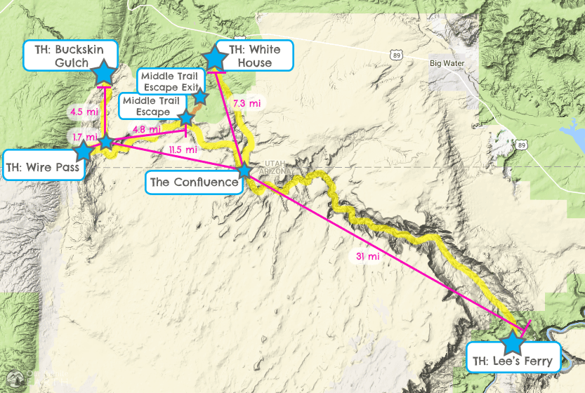

Points of interest and mileage:
- Wire Pass Trailhead to The Confluence: 13.2 miles – this is the most popular way to hike all of The Gulch
- Buckskin Trailhead to The Confluence: 16 miles
- Wire Pass Trailhead to Middle-Out Escape Exit: 6.5 miles
- The Confluence to White House Trailhead: 7.3 miles
- The Confluence to Lee’s Ferry: 31 miles
Day Hikes
While you don’t need to make an advanced reservation for a permit for a day hike, you do still need to get a day-use permit and leave it in your car. These can be accessed via self-serve envelope stations at the trailhead.
Wire Pass Trailhead to Buckskin Gulch (The Gulch, not the trailhead)
- Distance: 1.7 miles one way
- Elevation Gain/Loss: 206 feet
- Difficulty: Moderate
- Crowd Factor: Low
- Water: No
Wire Pass is a short trail that dumps you straight into the beginning of “the good parts” of The Gulch. It’s a shorter way to access Buckskin rather than using the actual Buckskin trailhead. This trail provides a “take a quick look” at Buckskin Gulch. Wire Pass Trailhead offers the most direct access to the gulch for a day hike. From the Wire Pass Trailhead, the trail is 1.7 miles before landing you into the gulch. From here you can just take a look around and go back or travel left/north towards the Buckskin Gulch Trailhead (4.5 more miles), or right/south towards The Confluence (11.5 more miles).
Wire Pass to Middle-Out Escape Exit
- Distance: 6.5 miles one way
- Elevation Gain/Loss: -380 (before scrambling)
- Difficulty: Strenuous
- Crowd Factor: Low
- Water: No
From Wire Pass to The Confluence (where Buckskin and Paria Canyons intersect) is 13.5 mi one way – while do-able, it’s also long for an out and back day hike. You can go from Wire Pass for 1.7 mi to Buckskin Gulch, then turn right and and head towards The Confluence and turn back at any time, or you can exit through the “Middle-Out Escape Route”, which is the only other access point to the 14mile long narrow portion of the gulch. It’s a difficult exit path and requires some steep rock scrambling (ropes are recommended), route finding, and is recommended only for experienced hikers without a fear of heights. Once you scale the rocks you’ll be rewarded with some petroglyphs that are thousands of years old! If you’re attempting this route, here’s a great detailed post all about it.
Weekend Or Long Day Hike
Wire Pass to White House (2 Days, 1 Night)
- Distance: 20.5 miles
- Elevation Gain/Loss: -720 ft, then 180 ft gain
- Difficulty: Moderate
- Crowd Factor: Low
- Water: Yes, unreliable
This hike can also be done as a day hike if you’re ambitious – we saw several hikers doing into Buckskin who didn’t come back out or spend the night, so have to assume that they then hiked out to White House. The White House Trailhead is the entrance to Paria Canyon. Choosing this route and you get to experience the most impressive parts of both the Paria Narrows and Buckskin Gulch. You could also start this hike at the Buckskin Gulch Trailhead if you want to hike the entirety of the gulch (and add 4.5mi to your trip). There are several campsites near The Confluence which can be used as the spot for your overnight if choosing this route.
Both of these trails are pretty flat and you don’t feel much like you’re hiking down hill either way, so whichever direction you choose is really up to you. One thing to keep in mind is that Buckskin is shaded almost all day whereas Paria is not, so you may want decide where you’re starting based on trying to avoid the sun.
If taking this route, you’re going to need to use a shuttle to get from White House back to your car at Wire Pass (more on shuttles below).
3+ Days
Wire Pass to Lee’s Ferry
- Distance: 47.7 miles one way
- Elevation Gain/Loss: -1,760
- Difficulty: Moderate
- Crowd Factor: Low
- Water: Yes, reliable
Again you can also start this hike at the Buckskin Gulch Trailhead if you want to hike the entirety of the gulch (and add 4.5mi to your trip), but the Wire Pass Trailhead still gives you access to all the good stuff. You’ll be passing through the best parts of Buckskin Gulch and then meeting Paria Canyon at the Confluence, and continuing through this canyon for the rest of the journey.
Safety & Weather
There are some very real dangers when hiking through Buckskin.

Flash Floods
Check the weather before you enter! If there is even remotely a chance of rain, do not enter. This area is prone to fast and deadly flash floods (you can see debris stuck between the canyon walls high above you from previous flash floods). The Narrows portion of Buckskin Gulch is 11mi long with only one exit if bad weather hits: the “Middle-Out Escape Route”. This the only way out of Buckskin if bad weather hits. The Middle Out Escape Route is in “the middle” of this stretch and is 6.5 miles south of the Wire Pass Trailhead. It requires steep rock scrambling to get out. Call the Paria Contact Station – (435)-644-1200 – before your trip for current conditions.
Quicksand & Sticky Slippery Mud
Quicksand likes to hang out “in the corners”, so that’s what you should avoid – which is difficult to do in Buckskin Gulch since it’s all “the corners”. None the less, try to avoided any edges or corners with rocks or canyon walls. Try to go straight down the middle and staying out of the pockets or areas where the water can pool.
Depending on the time of year when you go, there’s going to be mud. The majority of it is once you get closer to The Confluence and can be pretty slippery, roughly the consistency of pudding. There are some sections however where the mud is more aggressive and more sticky. These thicker mud pockets aren’t quicksand, but they can still grab you and suck you in. I got stuck in one section where I couldn’t get enough force to pull myself out without a steady helping hand. Pay attention to the footprints of the people who came before you (there will be lots) in order to get an idea of how far into the mud you can expect to sink.
Maps


Campsites
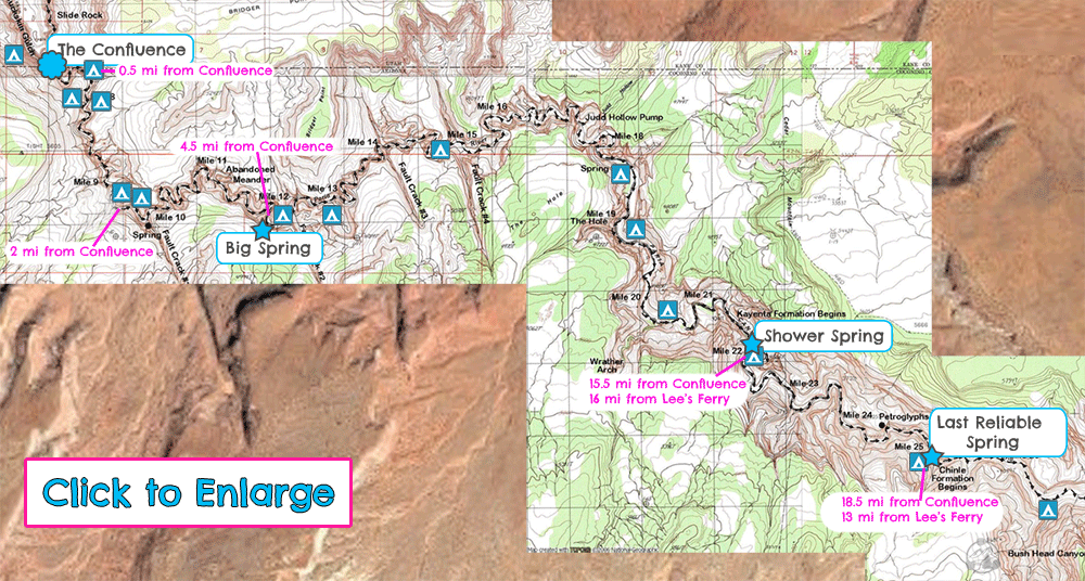
The BLM will provide you with a map of available campsites when you pick up your permit. This is the most up to date map with available campsites etc. once you get into Paria Canyon, but I found another map online that I thought was much more detailed and helpful: Tom’s Desert Maps.
I used a combination of both of these for our trip – the BLM map to show where the campsites are, and Tom’s map for other landmarks and mileage markers.
The closest campsite to Buckskin is just before The Confluence, just after the mouth of Buckskin when it opens up. Here the Gulch widens considerably and there’s sandy areas on both sides of the canyon raised up from the water level where you can camp. Given the size of this area, you could probably comfortably fit 3 separate groups here (one on the right, two on the left) and still have some bit of privacy. Both times that we’ve done this hike, there’s been someone camping here (but only one group) each time. So I think you should be able to find a spot to camp here unless it’s unusually busy.


Outside of this campsite at the mouth of The Gulch, the rest of the campsites are located within Paria Canyon after The Confluence.
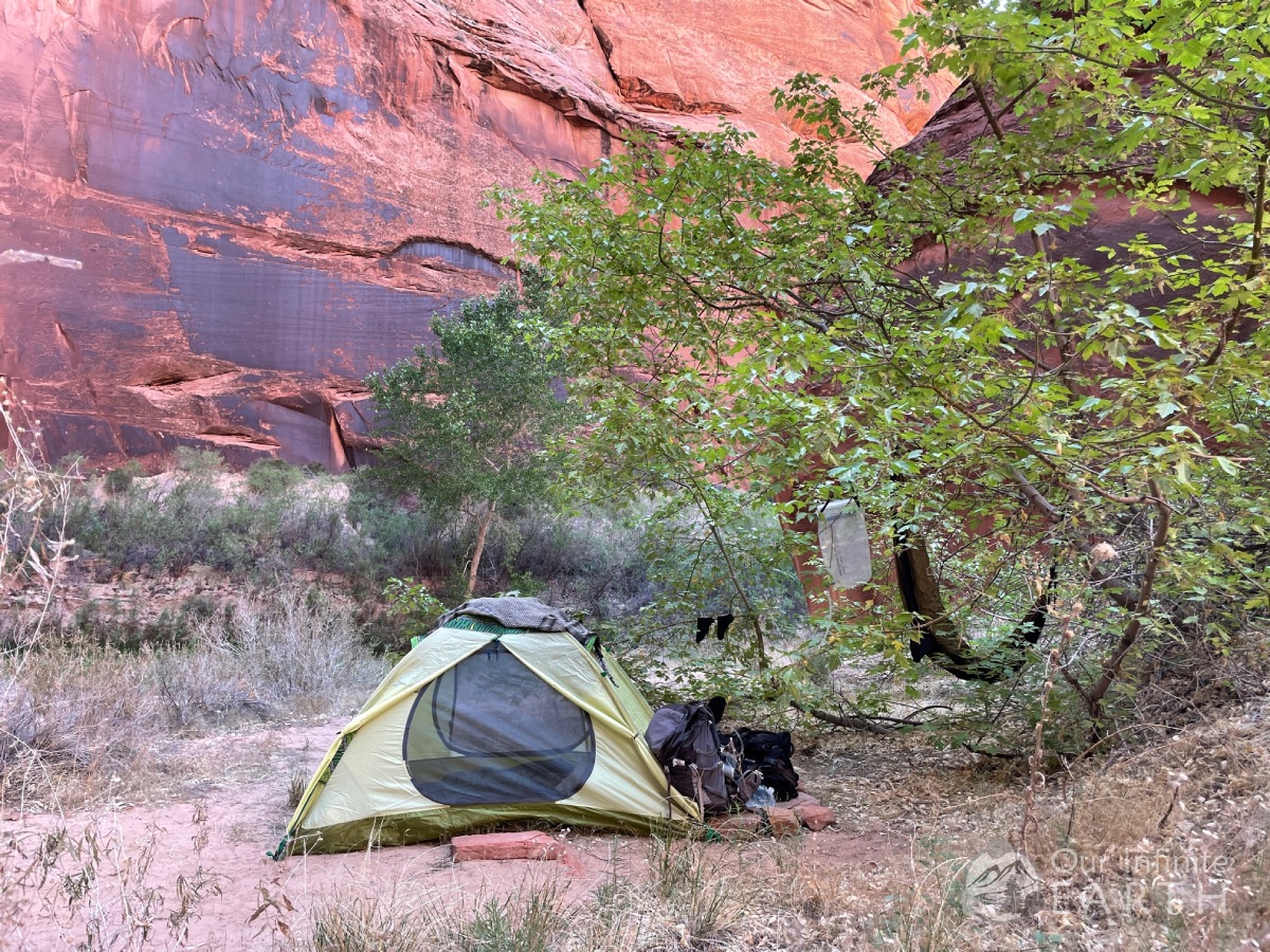

The campsites closer to the confluence are more obvious as more people have used them, but further into the canyon you go (if you’re hiking to Lee’s Ferry), some of the sites becomes harder to spot. It’s more just finding a piece of solid land up above the sides of the river where you’ll make as little impact on the surrounding area as possible.
Water Sources
There are no fresh water sources within Buckskin Gulch. Depending on the time of year, there will be some very muddy merky water that you’re hiking through, but I wouldn’t recommend drinking that water even with the best filter in the world as it’s massively gross.
Bring enough water with you to make sure you get through The Gulch. Once you get to The Confluence, water becomes more abundant. There are water pools within Paria Canyon that have flowing water through them and are much less gross. We’ve used this for water many times (filtered of course).
Once you get roughly 2 miles past The Confluence (heading towards Lee’s Ferry), there are lots more opportunities for water. In addition to the option of filtering the water on the canyon floor, there are also fresh water seeps and even springs throughout the canyon.
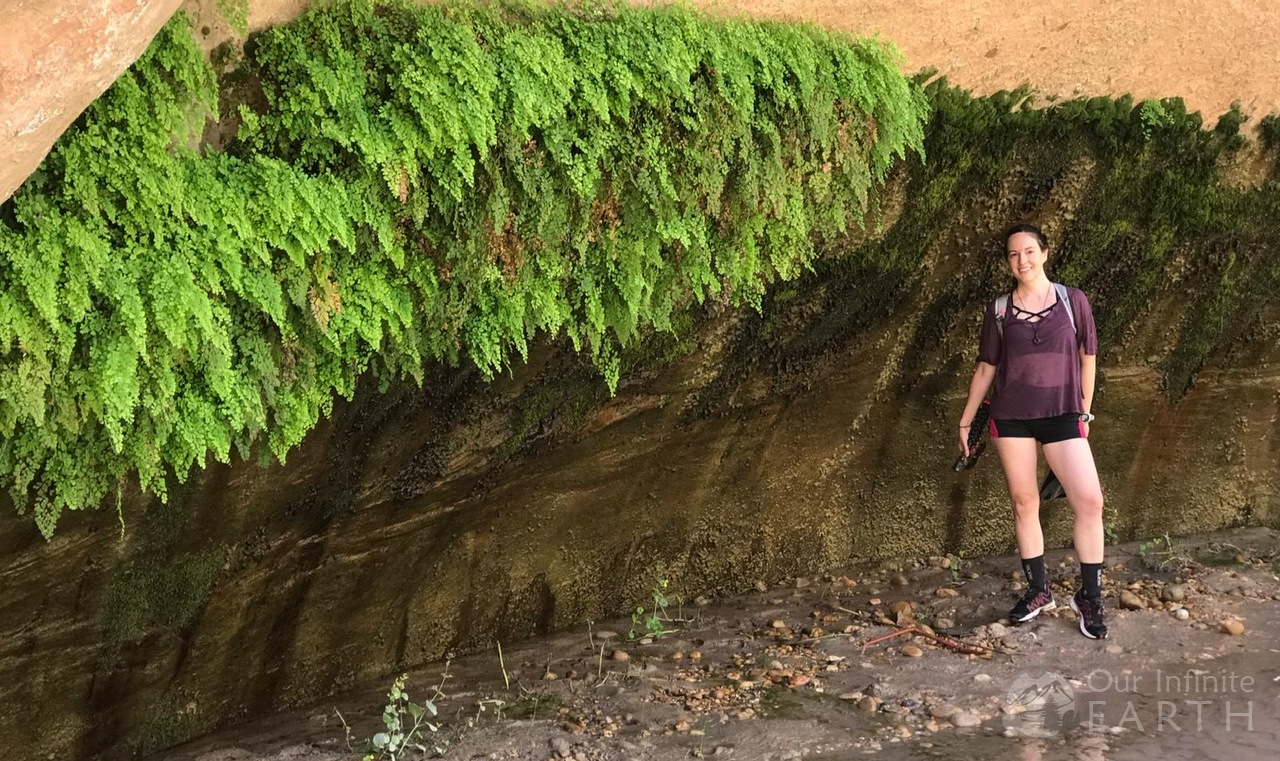

More about location the reliable fresh water springs and seasonal springs here.
Backpacking Gear
In addition to our:
These are the items that you’re gonna need on your trip:
Water shoes: Rubber Sole Mesh Water Shoes
Being in The Gulch, you’re going to get wet. While a lot of this may have dried out over the summer, the end near The Confluence is almost always muddy and wet. Having water shoes is a good idea so that you’re not force to continue to hike in wet boots.
Neoprene socks: 3mm, Calf- High
To go with your water shoes and protect your feet! I went with 3mm and wouldn’t recommend going any lower. They will add extra cushion in your water shoes and also will keep your feet warm. The 18″ height is also important because it helps to keep the silt and mud out. My fiancé got ankle socks and was getting stuff stuck in his socks constantly.
Gravity Water Filter: Platupus 4Liter (or similar)
This is such a time saver and allows you to no be so reliant on the fresh water springs. Just fill up one of the bladders when you get to camp and let gravity do the work! You’ll have 4 liters of fresh clean water for cooking or refilling your packs shortly.
Trekking Poles: Adjustable Trekking Poles
I personally don’t usually use trekking poles since I like to have my hands free, though I know many do. Trekking poles are very handy for this hike though since you’re going through water pools where you can’t see how deep they are, in case you get stuck in mud and need to get pulled out, or just for walking across the uneven rocky terrain.
What To Expect Along The Trail
In order to not be redundant, I’m just going to talk about hiking through The Gulch specifically here. If you’d like more details about the rest of this thru hike (from The Confluence to Lee’s Ferry), I go over this in much more detail in my Paria backpacking blog here.
Hiking through Buckskin Gulch is like no other experience I’ve ever had. Most slot canyons are pretty short, but Buckskin is relentless and seem to continue on and on and on.
s


Entering at Wire Pass itself starts off as a wash before getting to the canyon- no shade in this portion, but then there’s a few fairly narrow cliffs that soon widens into a sunny grotto with sand and trees. Look around for the ancient petroglyphs on the canyon walls here which are pretty cool (there are more further into Paria Canyon if you’re hiking all the way through to Lee’s Ferry).
Much of Wire Pass isn’t that impressive until you reach the entrance to The Gulch. Massive 200 ft tall sandstone rocks rise in front of you as if welcoming you into the cavern temple out of Raider’s of The Lost Arc. I don’t know how else to describe the towering walls of The Gulch other than the most beautiful and remarkable cathedral that has ever been created.


The further into the canyon you go, the higher the walls become. My favorite part of hiking Buckskin was the last 1 mile before The Confluence. This has some of the tallest and narrowest sections of the entire trail.
Depending on when you go (try to aim for when the water levels are low), The Gulch may or may not be full of water and mud in several spots. During our hike in June, it was almost completely dry until the end of the hike, but….
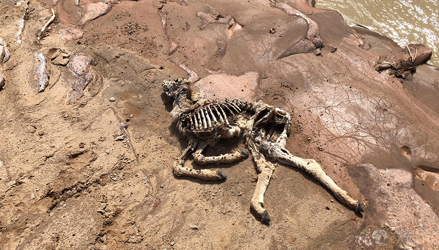
Sometimes there’s no way around the cesspools other than straight through. Buckskin is known for its cesspools – stinky muddy merky stagnant water full of bugs and possibly even dead animals. We met a hiker who had done this trail one year with high water levels and was going through a section called “the washing machine” where, when full, the water continues to churn – the water was chest high and he was stuck here with the rotting corpse of a dead deer.


Buckskin is also known for it’s mud. Thick, sticky shoe-grabbing mud. This is where trekking poles come in especially handy to help pull and push yourself out of sticky spots where the suction is so strong that you can’t free yourself.
The Middle Out Escape Route is roughly 6.5 miles into the hike from Wire Pass and is one of the lower points in The Gulch, thus is usually muddier and can have some deeper waters as you get closer to it. The purpose of this point is to be a way to escape from The Gulch in case of a flash flood (if you’re nearby). But that doesn’t mean it’s easy! Going up the Escape Route still requires some rock scrabbling along very steep slick rock. But it is an option if you’re looking for a way to shorten your hike. More info about using the Middle Out Escape Route here.


While The Gulch is known for being narrow, I was surprise at how many “open” grottos there were with trees and sandy “beaches”. There are a few scattered sporadically throughout which offers a nice place to rest if needed. You could probably even set up a campsite in one of these areas if you were really desperate even though you’re not allowed to camp in The Gulch (just to give an idea of the side of these sections).


Throughout the hike, if you look up, there will be tree branches and logs which are wedged high above you between the narrow canyon walls. These were placed there when water levels were high or during a flash flood when the water current was strong.


There’s also a big oil drum that’s wedge above a boulder that’s fallen into The Gulch creating a “tunnel” of sorts for you to walk through.


About 1/2 mile from the end of The Gulch is the boulder jam. This is where the at one point must have been a cave-in and this area is almost impassible – except for one hole where you can squeeze through the rocks. Just look for the orange rope! This will help to guide you under the jam and safely out the other side.


After the boulder jam is my favorite part of the entire hike because the walls rise even higher (must be at least 400-500ft) and get even more narrow. You almost feel like you’re trespassing through a tomb. The walls of the rocks becomes lightly striped with striations from years of being worn down by water. Some sections here are just shoulder-width wide and you can barely see the sunlight when you look up. It’s truly an incredible “religious” experience walking through this section of Buckskin.
If you haven’t encountered water and mud yet, you can plan to do so during this last section of The Gulch. As you get closer to the exit, water seems to exist here year round and the moisture of the air even changes to being damp.
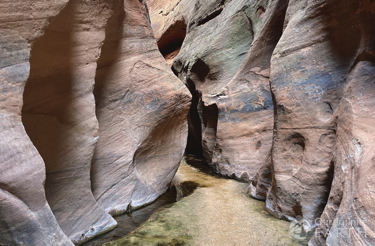

If you’re paying attention you may also feel some drafts of cold air coming into The Gulch from other deeper and darker areas of the canyon. This air was so chilly it felt like air conditioning!


The Gulch opens up again just before The Confluence with Paria Canyon. In this section is the first available (legal) campsites. The “banks” of the river house trees and other bushes and reeds and offer ample space for setting up camp up away from the mud and water.
If you’re not spending the night, then from here, you’ll be continuing to The Confluence and turning left to follow the fork which will take you out to the White House trailhead.
Backpacking VLog
Video diary of our backpacking trip in this area which includes exploring Buckskin Gulch and Paria.
