


The entire Panorama Trail goes from Glacier Point past several stunningly beautiful views and waterfalls, and down to the valley floor via The Mist Trail. You can do all or any piece of this hike depending on how much time you have and how vigorous you want your day to be. The trail has some of the best views of the valley in my opinion.
Overview
- Distance: 10-12 miles (depending on route)
- Type: Thru-hike or Out & Back
- Time: 5-8hrs
- Elevation at Trailhead: 7,200 feet/ 2,200 meters
- Elevation Gain: -3,200 feet/ 975 meters
- Difficulty: Difficult/ Hard
- Crowd Factor: Light-Moderate, Heavy at beginning and end
- Best Time: May-Sept
- Permits/Fees: No, Yosemite Entry Fee: $35
- Water: No
Directions to the Panorama Trail Head
The trail head starts at Glacier Point, which is at the end of a ridge high above the valley floor.
From the South entrance: Go approximately 17 miles to Glacier Point Road.
From the valley Follow 41 for 9 miles to Glacier Point Road on the left.
Follow Glacier Point Road to the end where there will be a large parking lot. The point is a popular area for people to take in the view – complete with tour buses. The beginning of the trail is off to the right if you are facing the point and is well marked.
What To Expect Along The Trail
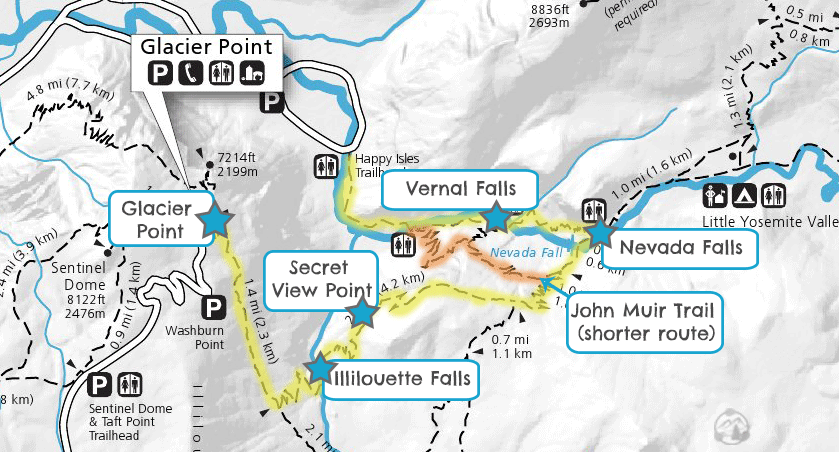
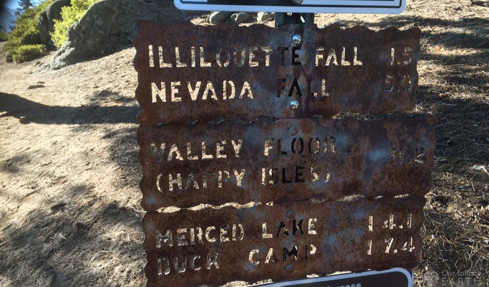
This trail really depends on how ambitious you want to be. The entire trail will pass Illilouette Falls, then go to Nevada and/or Vernal Falls, and then down the The Mist Trail to the valley floor.
Note: If you decide to do this entire trail, you’ll now be stuck 3,200ft below Glacier Point where your car is. To get back to your car, you can turn around and do the entire hike backwards again, find another trail back to the top (the shortest being the Four Mile Trail), take a pre-booked tour bus to the top, or coordinate and make sure you have a car at the bottom. There is no shuttle service going to Glacier Point.
The Full Panorama Trail (Glacier Point to Valley Floor)
- Distance: 9.5 miles (15.28 km) one way
- Type: Thru-hike
- Elevation at Trailhead: 7,200 feet/ 2,200 meters
- Elevation Gain: -3,200 feet/ 975 meters
- Difficulty: Difficult/ Hard
- Crowd Factor: Light-Moderate, Heavy at beginning and end
- Time: 5-8 one way
Pro Tip: I do not recommend doing the full trail unless you have a car waiting for you at the bottom or will be taking the bus to Glacier Point (which only runs at 8:30 am or 1:30 pm). I think the best thing to do is to go from Glacier Point to Nevada/Vernal Falls and then back again. It’s very beautiful, you still get all of the views, but you skip the crowded Mist Trail and the problem of being stuck at the bottom of the valley or on a schedule to catch the bus.
When we did this trail, we hiked the whole thing and regretted it. This was shortly after the shuttles stopped running to Glacier Point, so at the end of the trail we had the option of going back up the same trail (which would have been impossible before dark) or going up the Four Mile Trail which the park service recommended on their website as a “kick-ass alternate route”. We took the Four Mile Trail, — which is not 4 miles, it’s closer to 6 — and is nothing but switch backs for the entire 3,200ft up side of the mountain. Unless you’re a masochist, do not take the Four Mile Trail.
Glacier Point to Nevada Falls
This is the portion of the trail I recommend doing and then returning the same way.
- Distance: 12 miles/ 19.31km round trip
- Type: Out & Back
- Elevation at Trailhead: 7,200 feet/ 2,200 meters
- Elevation Gain: -1230ft/ 374 meters
- Difficulty: Moderate/Hard
- Crowd Factor: Light-Moderate
- Time: 6-10 hours round trip
Glacier Point to Illilouette Falls
If you just want a taste of this hike and to see some awesome views, you can just go to Illilouette Falls and back:
- Distance: 5 miles/ 8km round trip
- Type: Out & Back
- Elevation at Trailhead: 7,200ft /2,200m
- Elevation Gain: -1,400 feet/ 420 meters
- Difficulty: Moderate
- Crowd Factor: Light-Moderate
- Time: 2-4 hours round trip
Assuming it’s not too crowded, you might want to take in the view at Glacier Point before starting on the trail. It’s one of the more breathtaking viewing in Yosemite.
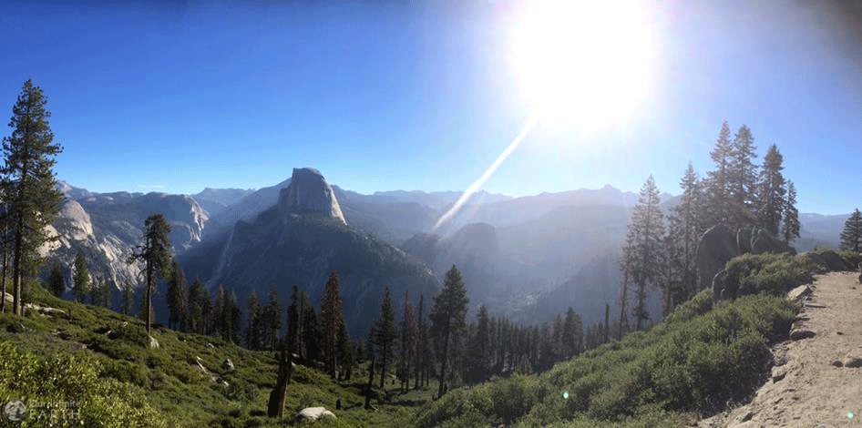
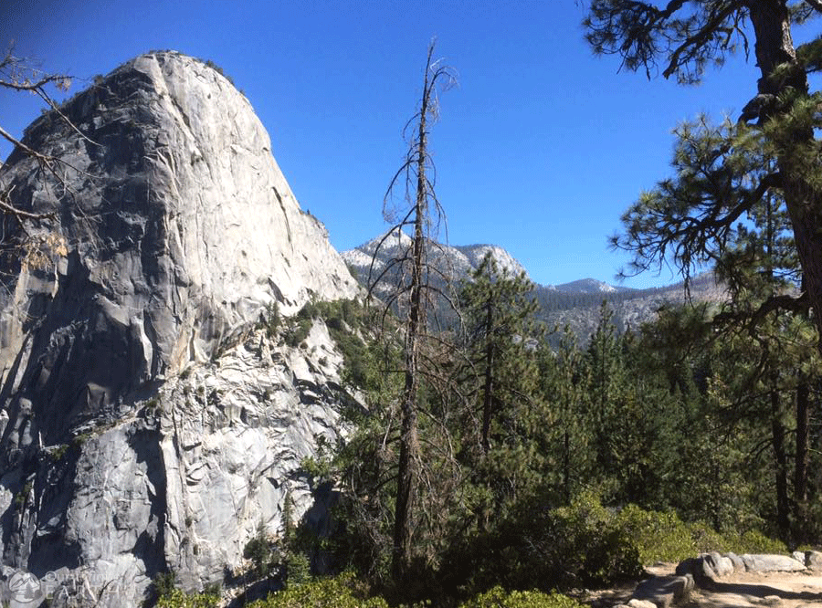
When you start off on the trail, it starts slightly descending almost immediately in a series of long switch backs (keep in mind you’ll have to travel up this on the way back). You’ll have stunning views of Half Dome and several waterfalls and can see Illilouette creek off to the right, which is ultimately where this trail is heading. The trail is packed dirt, flat and easy, and without much shade.
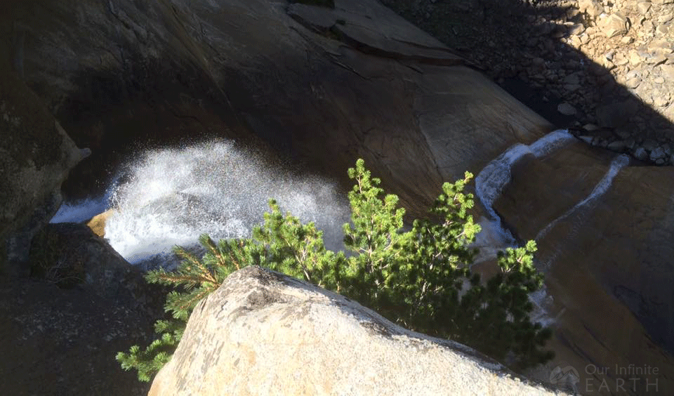
After about 2 miles, you’ll come to a junction and will follow the left path (clearly marked) to Illilouette Falls, which you’ll have a view of by now. In about another half mile, you’ll have your best view of Illilouette Falls as you stand on the canyon edge to the side of it.
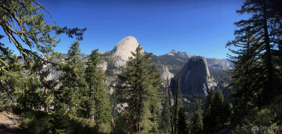
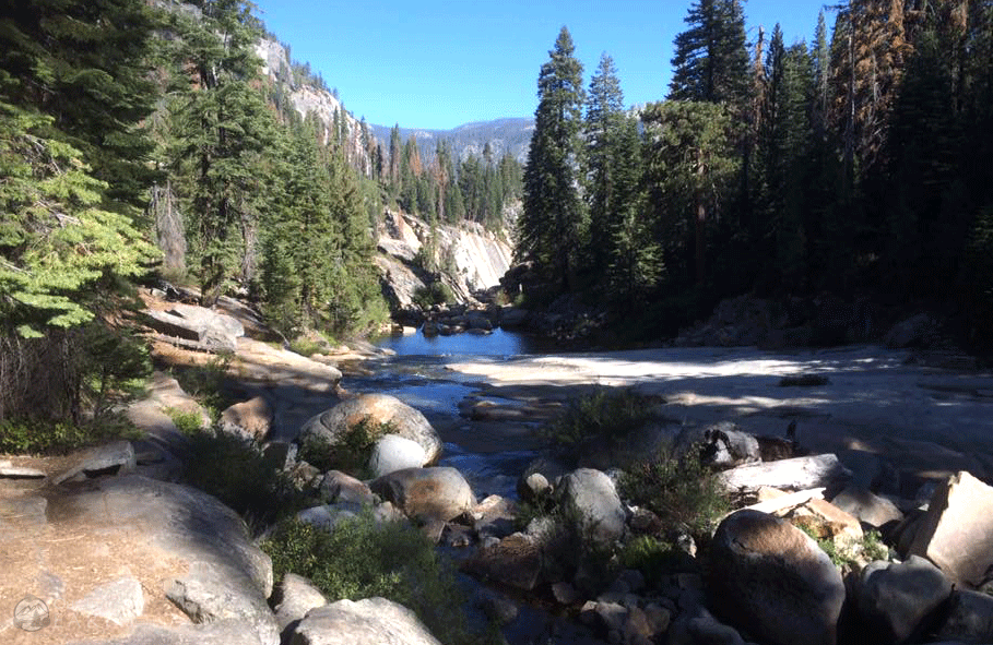
The trail continues to descend through the pine forest as you make your way to Illilouette creek, just above the falls. Here is a footbridge that will take you across the creek. The trail then start to move uphill and if you look back over the valley, you’ll have great views of North Dome and the Royal Arches.
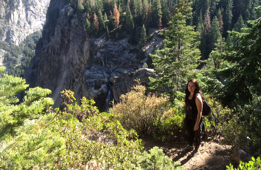
Pro Tip: There is an unmarked path about a 1/2 – 2/3 of a mile after you cross the bridge that’s worth stopping for. The path veers off to the left from the main trail through a field of waist-high manzanitas and ends with an amazing view off Panorama Cliff that’s one of the most expansive in all of Yosemite. The turn off is shortly after the condensed series of switch backs starts to ease-up.
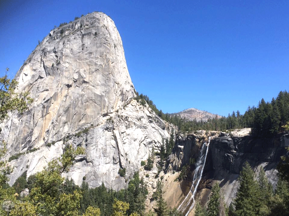
Back on the trail, it will continue uphill until reaching the crest of the hill (an elevation gain of 750 feet) and then continues slightly downhill again. Shortly there after you’ll be able to see the top of Nevada Falls, which is where you’re headed. There will be another junction point, again clearly marked, where you continue straight. The trail then passes through a few streams of varying depth depending on the season.
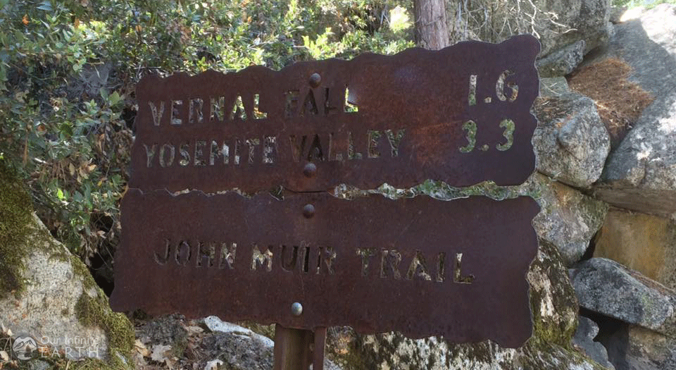
You’ll come to a junction with the John Muir Trail a little after 3 miles past Illilouette Creek. If you want, you can take the John Muir Trail to the valley floor at this point, but you’ll miss getting up close and personal with a few vivacious waterfalls. Instead, stay to the right and hike another 1/4 mi to the top of Nevada Falls. There’s a footbridge slightly above the falls which allows you for death-defying views from either side of the cliff.
Personally, this is where I’d turn around and head back the way we came, but if you have a car or bus ticket waiting for you at the bottom, then you’ll want to continue another 1/4 mi along the trail to where it intersects with The Mist Trail. There’s a bathroom here and another trail that also leads to Half Dome.
The Mist Trail will take you past Vernal Falls (also great view and photos ops!) back down to the valley floor through pretty much a steep rock staircase for the entire trail. It has beautiful views of both waterfalls and also expect to get wet as they spray on you! Once the stairs end, the path is level for the last 1.5mi or so to the end.
