


Hiking in the Valley of Fire State Park in NV is a very unique experience and a great way to see the attractions of the park. There are lots of incredible rock formations which create some stunning landscapes. It’s a relatively small park and most of it can be seen in just one day (things to do in Valley of Fire here).
But there aren’t very many hiking trails in the park. Plus, given the lack of cover and heat of the desert sun, all of the available trails are pretty short. Most of them are less than 2 miles and the longest trail in the park is just over 5 miles.
If you’re thinking about hiking in the Valle of Fire, make sure to bring lot of water with you. There are some trails that even have warnings that you should not hike them in excessive heat (temperatures can reach over 100 in the summer!)
Here are the available trails in the park:
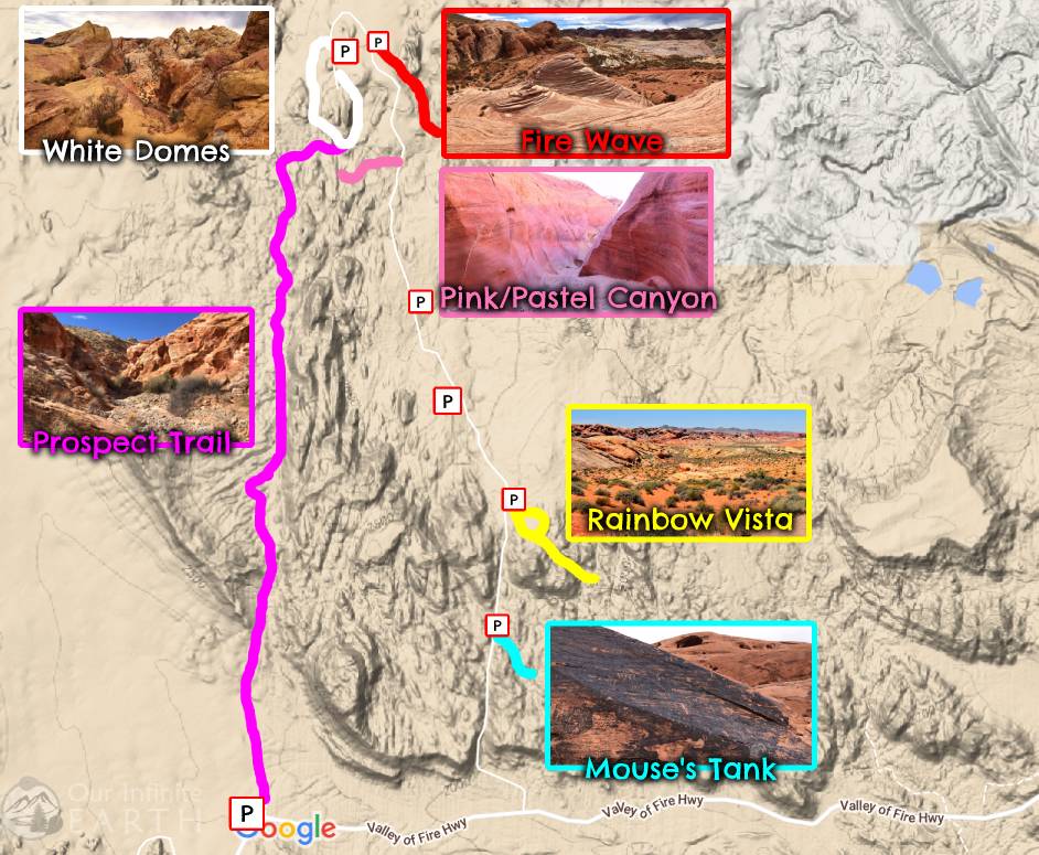
The Prospect Trail
Length: 5.5mi ONE WAY.
 This was our favorite hike in the park. Given the length of it, most people seem to avoid this hike, which meant that during our visit, it was pretty secluded and we had the trail to ourselves the majority of the time.
This trail stretches from White Domes to Valley of Fire Highway and essentially runs parallel to Mouse Tank road through a canyon. The canyon closer to White Domes is more narrow with tall sandstone walls of various colors. The walls becomes shorter and wider and eventually degrade into a wash when you get closer to the main road.
It’s a really pretty hike where you can get away from the crowds and see some beautiful colorful rock formations. Like all hikes in the park however, it’s pretty exposed to the elements, especially mid day when the sun is high above you. There are also a few areas where you may need to scrabble over some fallen rocks, or take a detour up and over the sides to get around the blocked trail.
The biggest negative of this hike is that if you’re to do the whole thing, you’ll end up almost 6 miles away from your car. And unless you plan on hitchhiking back, there’s no public transportation in the park. We found that the best thing to do was just to hike the top of the trail from White Domes and then turn around half way through and return to the start.
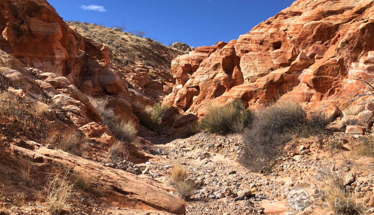
White Domes Loop
Length: 1.5mi loop
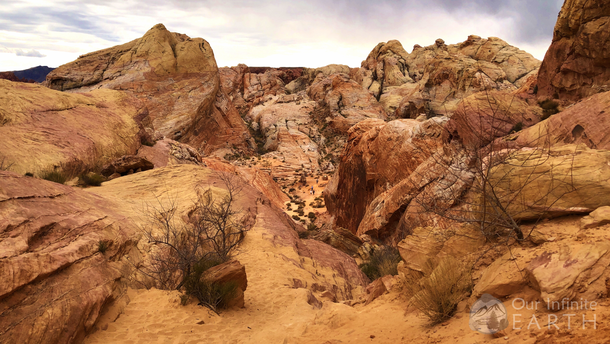 One of the most popular and cool trails in the park. The White Domes Loop trail is a short easy trail that takes you past old movie sets, towering canyon walls, and a short slot canyon. It’s a great way to get a little bit of a taste of everything the park has to offer. The trail starts at the White Domes parking lot and loops around through the large white dome rocks, through a slot canyon, across the desert, and then back to the parking lot. The trail has one slightly difficult section right at the beginning as you go down some stone stairs, but the rest of the trail ins mostly flat and easy.
The Fire Wave
Length: 1.5mi loop
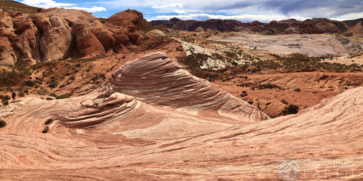 One of the most photographed places in the park. The Fire Wave Trail will take you to the instagram-famous Fire Wave, which is red and white zebra striped sand stone curving through the desert culminating with two knolls. It definitely feels a bit like the The Wave in Utah. This hike is completely exposed to the sun, no shade at all, and it’s not recommended to do it during the heat. The trail is mostly flat expect for the entrance/exit which descends down the side of a hill (which you then have to go back up again to get out). The Fire Wave itself is a pretty open area – you just follow the markers on the trail until you see it. Then there’s lots more opportunities to continue to explore the area if you choose.
Mouse’s Tank Trail
Length: .75mi out and back
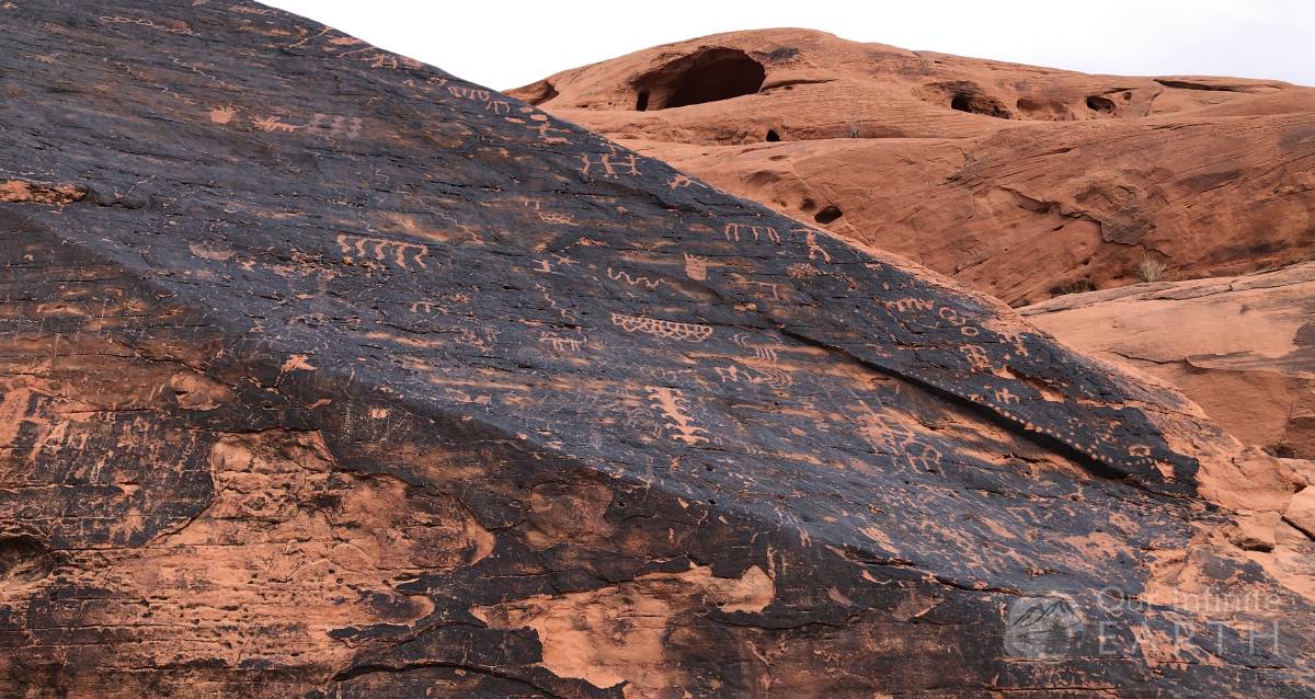 This is rather unexciting in itself. It’s very sandy and leads you through Petroglyph Canyon until you reach Mouse’s Tank, which is basically a hole in a rock that will store rain water which an outlaw used to survive off of long ago. The tank itself and the hike aren’t much to write home about, but the petroglyphs on the canyon walls are pretty cool. They’re EVERYWHERE in this canyon and well preserved. You don’t even need to do the whole hike if you just want to check out the petroglyphs.
Rainbow Vista & Fire Canyon Overlook Hike
Length: 1mi loop
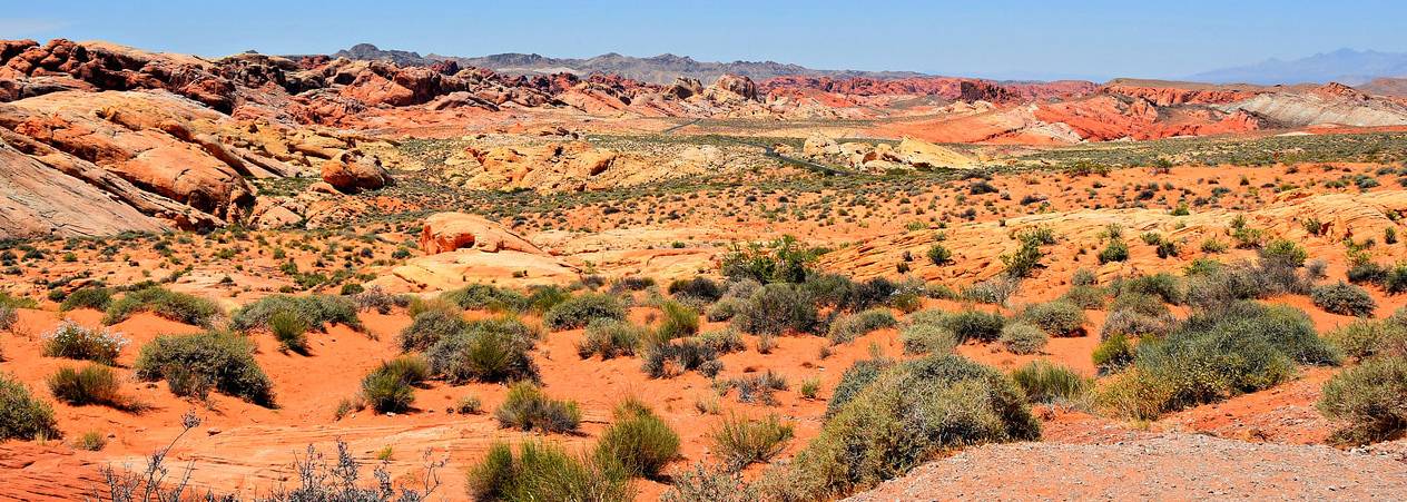 I didn’t think that this trail was much to write home about either – the Fire Canyon overlook which you can access via Fire Canyon Road is pretty beautiful and gives you an even better view than this trail in my opinion. This trail starts at the turnout for Rainbow Vista and set out east on a sandy trail between tall formations of red sandstones. The stones throughout the trail range in a variety of colors (hence the name Rainbow Vista). The loop goes through some open desert as you hike through the sand towards large rock formations ahead of you. Continue to hike in the direction of the rock formations on the other side of the desert and you’ll come to a camera trail marker. On the top of the white sandstone dune, you’ll be able to get a view of the surrounding landscape.
Pink/Pastel Canyon
Length: not set
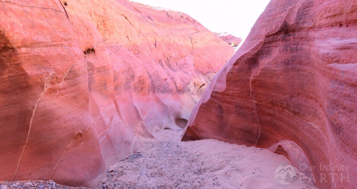 Pink (or Pastel) Canyon isn’t a true official trail, but it’s been visited so often that it might as well be. This is a very pretty (soft pink) slight slot canyon just down the street from The Fire Wave. It doesn’t have a set length since you can follow it for however long you want before turning around since it’s not an official trail.
To get there, from parking lot #3 follow the road west to the bottom of Wash No. 5 (there will be a small sign with a #5 on it). The canyon will be on the west side of the wash. As soon as you enter, you’ll find yourself in a beautiful pastel colored canyon.